Description


The Magic Town of Comala is one of the typical destinations in the state of Colima.
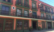
In its historic center you can see beautiful historical monuments of the 18th and 19th centuries among them the Church of Nogueras, the Former Hacienda de Nogueras, the Aqueduct (19th century), and city hall.

State: Colima
Coordinates:
19°19'15"N 103°45'37"W
Altitude: 740 meters above sea level
Area:
45.2 km²
Time Zone: Central Standard Time UTC-6
Population: 9,442 inhabitants (INEGI, 2010)
Area Code: 312
One of the gastronomic traditions of Comala are Los Botaneros; places where you buy drinks and all kinds of Mexican snacks such as pickled pork skins in vinegar, tacos, ceviche, guacamole, sopitos, and tostadas and much more while enjoying the sound of Mexican music like mariachi or banda.
The star of Comala cuisine is the Tatemado, a dish of pork loin seasoned with spices, bay leaves, pepper, garlic, vinegar, and chile pasilla. Another typical dish from the region is Comala style sweet bread. As far as drinks are concerned you can enjoy a fruit punch with mezcal and delicious coffee grown in the highlands of the region.
One of the main attractions of Comala is the beauty of its natural wealth. For the people of Comala caring for the environment is very important so for this reason it is possible to get in touch with the natural ecosystem of the region through ecotourism activities such as rock climbing, mountaineering, hiking, and bird watching; activities that can be enjoyed throughout the year in its four protected areas: the Colima Volcano National Park, El Jabali Wildlife Area, Sierra de Manatlán Biosphere Reserve, and Las Huertas de Comala Natural Resources of Protected Areas.
These natural areas are composed of walnut trees, parota, fig, Rosamorada, acacia, and are home to deer, coyote, boar, raccoon, woodpecker, chachalaca, calandria, sparrowhawk, and parrot among others. The traditional wealth of Comala lies in the ethnic groups in the nearby towns of Zacualpan and Suchitlán where indigenous groups fight for the preservation of their ancestral customs and their native language Nahuatl.
Since being named a Magic Village in 2002, Comala has increased its tourist infrastructure and has all of the tourist amenities and services.
How to get there?
Comala borders: Zapotitlán and Cuauhtémoc (North), Minatitlan (West) and Villa de Alvarez (South and East).
To get to Comala it is necessary to take the Guadalajara - Colima highway and then follow State Highway No. 16.
By air you have to options: The Playa de Oro International Airport located in the city of Manzanillo an hour and a half away, and Miguel de la Madrid National Airport located in Buena Vista Cuauhtémoc just 22 kilometers from the city of Colima.
Distance to Comala from other cities in Mexico
- Colima, Colima: 10 km.
- Ciudad Guzmán, Jalisco 81 km.
- Manzanillo, Colima: 105 km.
- Guadalajara, Jalisco: 205 km.
- Morelia, Michoacán: 410 km.
- Aguascalientes, Aguascalientes: 416 km.
- Querétaro, Querétaro: 471 km.
- Mexico City, Federal District: 675 km.
- Cuernavaca, Morelos: 685 km.
- Puebla, Puebla: 795 km.
Climate
The municipality of Comala has different climates; to the south it is warm and sub-humid, to the north it’s a humid climate, to the southwest it is moderate. The average annual temperature ranges from 23°C in January to 27°C in June. The rainy season occurs in the months of May to September.
What to pack?
Light clothing, sandals, and a hat are recommended if you prefer to do the walking tour of the town.
If you are planning ecotourism activities you must wear sports shoes, long pants, short- or long-sleeved shirt, a sweatshirt, insect repellent, and sunscreen. For the rainy months an umbrella or raincoat will be helpful.
Due to the proximity of the volcano Nevado de Colima, clothing for the cold weather is recommended if you plan to travel in the winter, as temperatures can reach below zero Celsius at night.
Activities and tourist attractions in Comala and its surroundings
Historic Center of Comala, City Hall, Main Plaza, Alejandro Rangel Hidalgo University Museum, Casa de Maquinas, Alberto Isaac House of Culture and Museum, Los Portales.
Colima Volcano Natural Protected Area National Park, El Jabali Natural Protected Area, Sierra de Manatlán Natural Protected Area Biosphere Reserve, Las Huertas de Comala Natural Protected Area.
Ecotourism Activities: Hiking and wildlife observation. Ecotourism Sports: Mountaineering (Mountain climbing).
Nogueras neighborhood: Nogueras Cultural Center, Former Hacienda de las Nogueras, Museum of the Former Hacienda de las Nogueras, Former Hacienda de las Nogueras Ecopark, Former Hacienda de San Antonio and Aqueduct, Former Hacienda Settlers, Nogueras Church, Parish Church.
Zacualpan neighborhood, Zacualpan Cultural Center El Fortin, El Puente que da a los Aguajes.
Town of Suchitlán (12 km from Comala), Suchitlán Community Museum.
Carrizalillo Lake, Santa María Lake.
Feasts and Celebrations
January 25: Feast of Santo Santiago en Zacualpan.
February 2: Celebration of Candelaria in Suchitlán.
May 15: Rodeos in La Caja.
September 15 and 16: Celebration of Mexican Independence Day.
October 31 – November 2: All Saints Fair, Day of the Dead.
December 12 - December 15: Celebrations in honor of the Virgen de Guadalupe, Patroness of Mexico.